suzhou industrial park an emerging chinese model new town
China has been undergoing rapid urbanization in the last three decades, with the percentage of urban population surging from 20.4% in 1982 to 52.6% in 2013. The trend continues with more than sixteen million rural residents moving to urban area each year in what geographer David Harvey regarded as ‘the largest mass migration the world has ever seen.’
China has been undergoing rapid urbanization in the last three decades, with the percentage of urban population surging from 20.4% in 1982 to 52.6% in 2013. The trend continues with more than sixteen million rural residents moving to urban area each year in what geographer David Harvey regarded as ‘the largest mass migration the world has ever seen.’ The massive urbanization has resulted in an unprecedented construction boom and the emergence of numerous new towns across the country. At the beginning of the twenty-first century, the Chinese government announced that it would build 20 new cities each year in the next 20 years; therefore approximately 400 new cities would emerge by 2020. These ambitious new town projects were not only created to house the swelling population, but also to sustain economic growth in the major cities they serve. Recognizing its enormous impact on Chinese society both in terms of challenge and opportunity, Premier Keqiang Li highlighted ‘urbanization’ as the keyword of economic restructuring in his political agenda after he took the post in 2013. He called for a more sustainable approach to the country’s mass urbanization to create new venues for jobs, consumption, and investments, to balance mega-cities with small towns, and to correct economic disequilibrium between coastal and inland regions.
The pursuit of a sustainable path of urbanization in China has actually accompanied the growth of urban population. Since the 1990s, the central and local governments in China have created a number of high-profile model city projects, using them as experiments of urban planning and development as well as stimuli of economic growth and transformation, and hoping they would generate replicable experience for the rest of the country. The Suzhou Industrial Park (SIP) was one of the earliest and successful comprehensive new town projects. It provides a remarkable example of how urban planning and design can trigger the economic engine and transform a sleepy tourist destination into an economic juggernaut.
This paper will trace the development of SIP in the last two decades. By analyzing the urban design and development strategies of this modern new town, the case study will cut a cross-section of the ongoing massive new town movement in China and examine the role of planning in urban transformation and economic development.
CREATION OF SIP
SIP started as a project resulting from top-level inter-governmental collaboration between China and Singapore. Such partnership was not only built on an economic foundation, but also based on a presumed cultural affinity because the majority of Singaporean residents are Chinese immigrants or descendants. The Chinese government has long admired Singapore government’s national economic development strategies and has tried to imitate them. In 1992, Deng Xiaoping, the former General Secretary of China’s Communist Party, famously said ‘We can inspire ourselves using the Singaporean social model and then do better’ when he visited Shenzhen. Deng was especially interested in how the Singapore government achieved rapid economic growth and industrial transformation and maintained its dominance in the social and political sphere as well. Singapore’s version of ‘authoritarian capitalism’ was perceived by Chinese political leaders as an alternative to the Western ‘free market capitalist’ system. China’s administration was also keen to learn from Singapore’s policies and strategies to attract Foreign Direct Investments or FDIs.
Meanwhile, seeking to expand its economic interest and political influence beyond its limited territory, Singapore government was also in search of investment and development opportunities overseas. Based on an overarching ‘Regional Industrial Park’ program, the Singapore government had planned to build a few industrial parks in Vietnam, Indonesia, India, Thailand, and China. These industrial parks would be modeled after Jurong Industrial Estate, which has achieved remarkable success in attracting FDIs since its inauguration in the 1960s and which has continued to build up Singapore’s experience in housing and industrial development and management in the context of economic globalization.
In February 1994, China’s Vice Premier Li Lanquing and Singapore’s Senior Minister Lee Kuan Yew signed two highly publicized agreements, which aspired to build ‘a world-class modern international industrial park modeled after Jurong Industrial Estate in Singapore.’ With the location of their operations by industrial transnational corporations in this new industrial park, the Chinese government could benefit from development effects such as employment generation and technology transfer, while Singapore could financially benefit from sale or leased of the industrial units with profits generated thereby eventually supplementing its domestic economy in the long run. For the Singapore government, a joint new town project was also an opportunity to improve bilateral government-to-government diplomatic ties with Beijing.
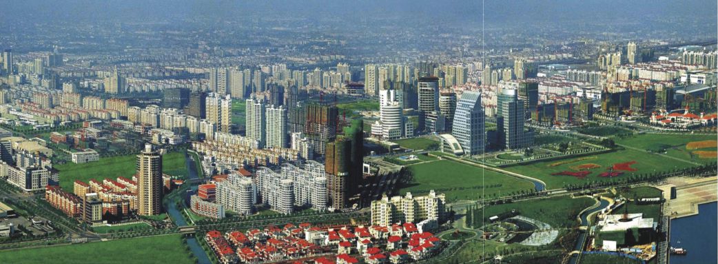
This ambitious 20-billion-dollar project, then known as Singapore Suzhou Industrial Park, is located in the east of the scenic historic city of Suzhou and is only 80 kilometers west to Shanghai. It occupies an area of seventy square kilometers, originally marshy and agricultural land. The proximity to Shanghai, China’s economic engine and financial center, was apparently one of the primary factors in the selection of the site as it was expected to provide competitive advantage in attracting industrial investments.
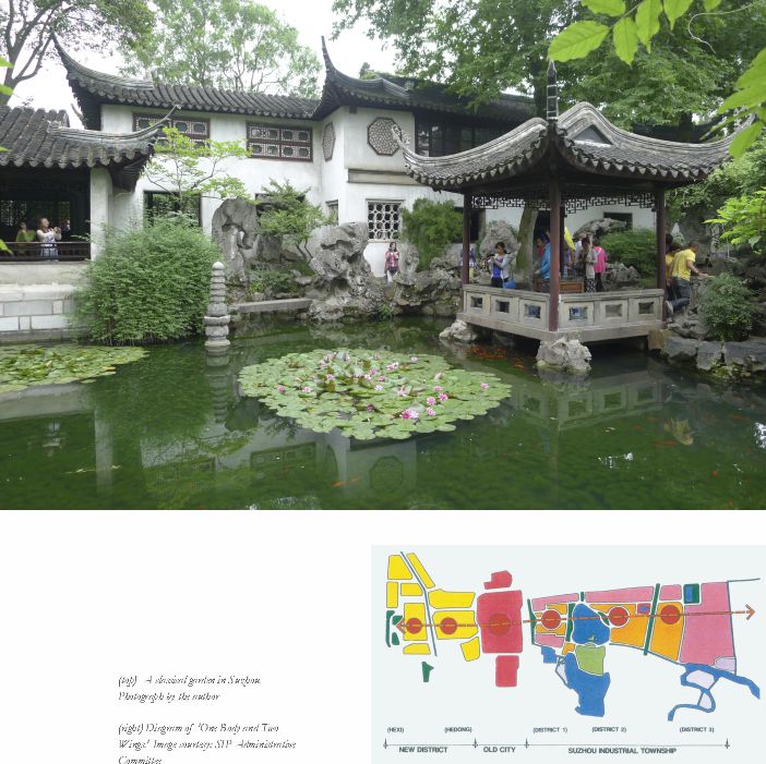
Establishing SIP at the current site also fulfilled the vision plan for Suzhou known as ‘One Body and Two Wings’ proposed a few years earlier. This comprehensive plan envisages two new towns (wings) flanking the center city (body), one to its west and the other to the east, forming a linear city. The old city of Suzhou, with a total area of 14.2 square kilometers, was first built in 514 BC and has always been a culturally significant city during its 2500 years of history. It is home of numerous Chinese Classical Gardens, some of which have been named UNESCO World Heritages. The city also features a traditional urban fabric known as a ‘double-chessboard’ structure defined by two overlapping grids, one consisting of streets and the other canals. The extensive canal network has led to the city’s prosperity and brought the city’s reputation as the ‘Venice of the East.’ The continuing growth of its urban population and the demand of economic development in the last few decades, however, posed a threat to the city’s historic heritages and the urban pattern its citizens rely on. The concept of ‘One Body and Two Wings’ was intended to preserve Suzhou’s historic urban fabric by channeling industrial and housing development to the new towns yet still maintaining its continuity as a whole city. The SIP in the east and the Suzhou High-Tech District in the west — established in 1990 — constitute the two ‘wings’ of Suzhou.
SIP was given the status of one of China’s Special Economic Zones (SEZ), which offers policies and incentives different from the rest of the country to encourage offshore production within self-contain industrial estates. Singapore and China each formed their economic consortiums as shareholders of this new town, consisting primarily of their respective state-owned corporations. The two consortiums then established a joint venture China-Singapore Suzhou Industrial Park Development Corporation (CSSD) as an authorized land developer on January 10, 1995, and the Suzhou Industrial Park Administrative Committee was formed to serve as the local agency of governance.
SIP MASTER PLAN AND ITS
DEVELOPMENT
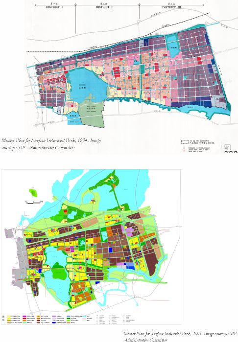
The development of Suzhou Industrial Park has been influenced by three master plans. In 1994, the first master plan was drawn up by Singapore Urban Redevelopment Authority along with Jurong Environmental Engineering and SIP Planning and Construction Bureau. The area, sometimes known as China-Singapore Collaboration Area or ‘super-development’ zone, covers about 70 square kilometers – later expanded to 80 square kilometers – in which Singaporean institutions were the primary shareholder. In 2001, SIP Planning & Construction Bureau and Jiangsu Urban Planning & Design Institute prepared a revised plan after the Chinese consortium became the primary shareholder. The plan area was expanded to 288 square kilometers, with the China-Singapore Collaboration District surrounded by three townships: Loufeng, Weiting, and Shengpu. In 2006, a master plan for Eastern New City and a SIP Zoning Plan were prepared by China Urban Planning & Design Institute to consolidate the last version.
The 1994 plan laid the foundation of SIP’s development. It focused on the core area to establish a ‘Multi-center Linear Structure’ that extended Suzhou’s urban axis eastward. The area would be developed in three phases, also in a linear manner from west (adjacent to Suzhou Old City) to the east (bordered by a national highway to Shanghai), with the centers of all these phases located on the axis. They constituted an urban and landscape axis, linking the city’s new Central Business District, governmental center, commercial center, high-density neighborhoods, and parks.
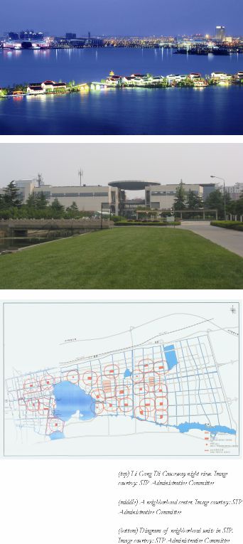
The plan also delineated a hierarchical organization of the city, following the planning concepts of ‘new town’ and ‘neighborhood unit’ in Singapore’s planning system to provide four levels of public facilities: region, district, neighborhood, and cluster. Each of the three districts, developed in the three phases respectively, would house 33,000-100,000 households. Each neighborhood would include 8500 households, laid out around the neighborhood center with public facilities serving a radius of 400 meters. Each cluster would have around 700 households, and is equipped with cluster-level public facilities. The target population for the city was 600,000, and citizens were to be supported by abundance of job opportunities supplied by the industries in the zone.
In terms of development sequence, the 1994 plan introduced an approach suitable for a model giving priority to industries. It meant infrastructure should be built first, then industrial land, then with the flowing-in of workers, residential areas would be built, and finally commercial facilities, once the influx population reached a certain level. For instance, considering the region’s relatively low ground, the entire Collaboration Area was raised by three feet through massive landfill to protect the city from floods. Once the urban framework of a new city was laid out, construction began. The first phase of development focused on the area of about 2,000 acres between the old city and Jinji Lake. Jinji Lake, a four-square-mile lake, was completely redesigned to build state-of-the-art waterfront landscapes. It became the jewel in the crown of the entire city.
At the turn of the 21st Century, SIP went through a significant transition. Despite its impressive accomplishment in attracting FDI since its inauguration, the zone continued to report substantial financial losses, and its state worsened after 1997 when the Asian Financial Crisis impacted the economies across the Asian Pacific Rim. More importantly, SIP faced competitions of other special economic zones in the region, particularly another industrial estate in Suzhou, Suzhou High-Tech District. As a result, the Singapore government decided to disengage itself from this project. Holding 65% of joint venture, the Singapore consortium dropped its share to 35% while its Chinese partner picked up the difference to become the major shareholder. Nevertheless, the inter-governmental collaboration continued, and soon SIP was able to extricate itself from the financial predicament and began to generate profits once more.
SIP’s transformation under the new management began with a new master plan. The 2001 plan covered an area of 288 square kilometers. It not only provided SIP with more developable land, but also addressed the connection of SIP with its regional context. SIP moved beyond a segregated industrial park to exercise greater influence on Suzhou’s development at large. Among the new districts included in SIP, the area around Dushu Lake in the south was identified as a Higher Education District, and the area around Qingjian Lake in the North was slated for ecological development and leisure.
SIP MASTER PLAN AND ITS
DEVELOPMENT
The development of Suzhou Industrial Park has been influenced by three master plans. In 1994, the first master plan was drawn up by Singapore Urban Redevelopment Authority along with Jurong Environmental Engineering and SIP Planning and Construction Bureau. The area, sometimes known as China-Singapore Collaboration Area or ‘super-development’ zone, covers about 70 square kilometers – later expanded to 80 square kilometers – in which Singaporean institutions were the primary shareholder. In 2001, SIP Planning & Construction Bureau and Jiangsu Urban Planning & Design Institute prepared a revised plan after the Chinese consortium became the primary shareholder. The plan area was expanded to 288 square kilometers, with the China-Singapore Collaboration District surrounded by three townships: Loufeng, Weiting, and Shengpu. In 2006, a master plan for Eastern New City and a SIP Zoning Plan were prepared by China Urban Planning & Design Institute to consolidate the last version.
The 1994 plan laid the foundation of SIP’s development. It focused on the core area to establish a ‘Multi-center Linear Structure’ that extended Suzhou’s urban axis eastward. The area would be developed in three phases, also in a linear manner from west (adjacent to Suzhou Old City) to the east (bordered by a national highway to Shanghai), with the centers of all these phases located on the axis. They constituted an urban and landscape axis, linking the city’s new Central Business District, governmental center, commercial center, high-density neighborhoods, and parks.
The plan also delineated a hierarchical organization of the city, following the planning concepts of ‘new town’ and ‘neighborhood unit’ in Singapore’s planning system to provide four levels of public facilities: region, district, neighborhood, and cluster. Each of the three districts, developed in the three phases respectively, would house 33,000-100,000 households. Each neighborhood would include 8500 households, laid out around the neighborhood center with public facilities serving a radius of 400 meters. Each cluster would have around 700 households, and is equipped with cluster-level public facilities. The target population for the city was 600,000, and citizens were to be supported by abundance of job opportunities supplied by the industries in the zone.
In terms of development sequence, the 1994 plan introduced an approach suitable for a model giving priority to industries. It meant infrastructure should be built first, then industrial land, then with the flowing-in of workers, residential areas would be built, and finally commercial facilities, once the influx population reached a certain level. For instance, considering the region’s relatively low ground, the entire Collaboration Area was raised by three feet through massive landfill to protect the city from floods. Once the urban framework of a new city was laid out, construction began. The first phase of development focused on the area of about 2,000 acres between the old city and Jinji Lake. Jinji Lake, a four-square-mile lake, was completely redesigned to build state-of-the-art waterfront landscapes. It became the jewel in the crown of the entire city.
At the turn of the 21st Century, SIP went through a significant transition. Despite its impressive accomplishment in attracting FDI since its inauguration, the zone continued to report substantial financial losses, and its state worsened after 1997 when the Asian Financial Crisis impacted the economies across the Asian Pacific Rim. More importantly, SIP faced competitions of other special economic zones in the region, particularly another industrial estate in Suzhou, Suzhou High-Tech District. As a result, the Singapore government decided to disengage itself from this project. Holding 65% of joint venture, the Singapore consortium dropped its share to 35% while its Chinese partner picked up the difference to become the major shareholder. Nevertheless, the inter-governmental collaboration continued, and soon SIP was able to extricate itself from the financial predicament and began to generate profits once more.
SIP’s transformation under the new management began with a new master plan. The 2001 plan covered an area of 288 square kilometers. It not only provided SIP with more developable land, but also addressed the connection of SIP with its regional context. SIP moved beyond a segregated industrial park to exercise greater influence on Suzhou’s development at large. Among the new districts included in SIP, the area around Dushu Lake in the south was identified as a Higher Education District, and the area around Qingjian Lake in the North was slated for ecological development and leisure.
URBAN DESIGN IN SIP
Suzhou Industrial Park was arguably the first new town project in China that extensively used the tool of urban design in its developments. An elaborate review system was established to make sure all projects, from the Central Business District to residential areas, and from infrastructure to landscape design, are regulated under the master plan, and each piece is a good addition to the city. The urban designs also looked after building designs and suggested contemporary styles to maintain consistency in the urban landscape. The city is also characterized by an extensive network of landscape and public facilities, meant to establish a high standard in the built environment. All these measures have distinguished SIP from other new towns in China, were lauded as the ‘Suzhou model’ and have now been emulated by many new town projects.
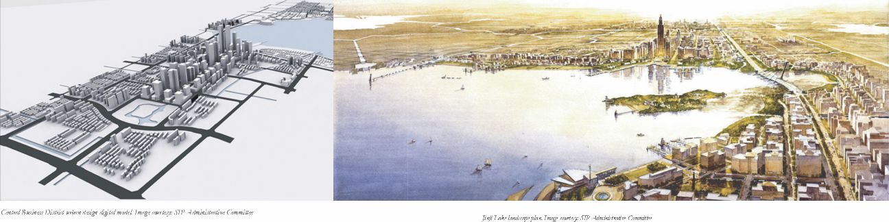
Two areas in SIP, the Central Business District (CBD) and Jinji Lake, demonstrate the project’s dedication to exemplary urban design. The CBD is located on the city’s central spine in the west of Jinji Lake with office towers lined up along a boulevard. A detailed urban design guideline was prepared prior to development, which defined the parameters of the buildings on each parcel including height, setback, location of the tower, pedestrian and car entrances, and even colors and materials of the façades. Building heights were regulated in such a way that they could form an impressive skyline with buildings escalating from the west (close to the historic city center) to the east (near Jinji Lake). A 900-foot tower, known as the ‘Oriental Gate’, terminates the axis at the lakefront. Most office buildings along the boulevard have been completed. Constructions began recently on a large shopping mall and a cluster of office towers around the Oriental Gate, some of which would be even taller than the Gate, forming an impressive skyline along the lake. The urban spine extends across Jinji Lake to form a high-density retail and entertainment zone. The city’s newly completed metro line connects SIP along this east-west axis.
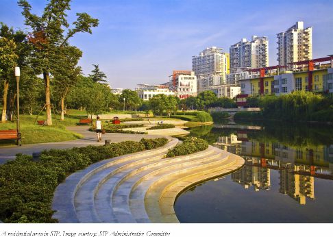
Jinji Lake itself is a showcase of landscape design. The American firm EDAW’s award-winning landscape planning and design delineated a vision of developing this 11.5-square-kilometer area, including a lake of 7.4 square kilometers and its surrounding area, into one of China’s largest and finest urban lakes, and made it the core of SIP. The majority of the lakeside area is reserved for public spaces, consisting of eight parks with different themes. The western side of the lake is bordered by a promenade and woods; the southern side features Li Gong Di, a beautiful causeway flanked by numerous restaurants, bars, and galleries; and the northeastern side is dotted with a few large-scale public buildings including the Science and Cultural Center and the Convention Center; while the Eastern side is dominated by a children’s park with a Ferris wheel among others. Together these parks provide 17 kilometers of pedestrian paths and 25 kilometers of bike paths. Water plays a unique role in shaping the urban landscapes of this new town as in the historic towns in South-Yangtze River Delta Region. This tradition was re-interpreted with contemporary designs and larger-scale landscapes in SIP. Placing priority on landscape development as part of the city’s infrastructure has proved a successful strategy of SIP as landscape significantly increases the value of land, generating more revenue for ensuing projects.
The residential areas in SIP are organized based on the principles of Clarence Perry’s concept of Neighborhood Unit. Perry’s idea referred to a relatively low-density neighborhood centered on school and community and bound by vehicular thoroughfares, with houses laid out within a quarter-mile radius from the neighborhood centers. When the Neighborhood Unit was introduced to Jurong Industrial Estate in Singapore, it was used for residential areas consisting of 4000-7000 households; most residents would then live in public housing complexes. When this concept was brought to Suzhou, the density grew to 8500 household per neighborhood unit, each placed around a ‘neighborhood center’ with a 400-meter service radius. The neighborhood centers house basic amenities like grocery stores, banks, pharmacies, and bookstores, as well as other services like barber shops and small clinics. Schools are located adjacent to the neighborhood centers. A regional shopping center is planned for each district serving multiple neighborhoods. This hierarchical order has provided the residential areas a rigorous organization able to allocate resources of public services logically and efficiently.
The network of neighborhood units in SIP, however, was not intended to encourage Transit-Oriented Developments, which is a missed opportunity. In fact, SIP is essentially a hybrid of Western suburban model and the density and building typology of Asian cities. The city is laid out on super-blocks occupied by gated communities or corporate campuses. Uses are segregated, and retails are contained in neighborhood centers or regional shopping malls. Although not really automobile-dependent, SIP is not easy to get around without a car except in the Central Business District. Although the first metro line in Suzhou was completed in 2012, and runs along the city’s East-West axis, traffic and parking remains a problem in SIP.
NEW TOWN AS ECONOMIC BUILDING
Suzhou Industrial Park became a ‘model’ in China’s massive urbanization first and foremost because of its economic success. Its Gross Domestic Products has grown at an incredible rate of over 30% annually since its inauguration. Occupying only 3.4% of land in Suzhou and accounting for just 5.2% of its population, SIP contributes more than 15% of Suzhou’s total GDP. It continued to rank No. 1 in China’s ‘most competitive Economic Development Zones.’ In 2001, Newsweek named Suzhou as one of the nine emerging High-tech cities in the world, and stressed SIP’s role in this endeavor.
Urban planning and design played a significant role in SIP’s economic accomplishments. Unlike many economic development zones or high-tech industrial parks in China, SIP was designed as a balanced and self-contained city from the beginning. The plan referred back to Ebenezer Howard’s Garden City concept, yet addressed the new context of globalization. Therefore, housing, commercial, and public services are developing in parallel to industrial and business with the rapid influx of FDIs. A series of masterplans laid out the blueprint for its urbanization, prioritized infrastructure, and allocated resources logically to support the city’s continuing growth. Numerous urban and landscape designs provided further guidance for the city’s development, enhanced its environments, and boosted land values. In this case, economic development and city building reinforced each other and worked really well to make SIP China’s ‘model new town.’
The systematic planning and design also distinguishes SIP from many other new towns in China, which often appear dynamic but are basically chaotic and segregated from the old city. In Suzhou, the preservation of the historic city center and the development of the new town are inseparable. The economic vitality and financial success of the new town have rejuvenated the old city while protecting its historic legacies. In turn, the old city supports SIP’s gradual growth, particularly in its early phases, by providing necessary infrastructure and urban amenitiess. Their mutual enriching relationship is among the other strengths of Suzhou that won the city the 2014 Lee Kuan Yew World City Prize. With its successes as well as the remaining issues typical of Chinese new towns, Suzhou Industrial Park represents a remarkable sample of China’s ongoing urbanization.
Dr. Zhongjie Lin is Associate Professor of Architecture & Urbanism at the University of North Carolina at Charlotte and Director of its Urban Design Program. He is a 2013 Guggenheim Fellow.
China has been undergoing rapid urbanization in the last three decades, with the percentage of urban population surging from 20.4% in 1982 to 52.6% in 2013. The trend continues with more than sixteen million rural residents moving to urban area each year in what geographer David Harvey regarded as ‘the largest mass migration the world…